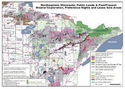
Click on link to enlarge the map. Note the footprint on the edge of Lower Red Lake - within sovereign reservation boundaries
| mcea_mining_footprint_march2009.pdf |
In 1997, I received two packets of documents from a small urban coalition of Red Lakers who were questioning the reasons for the depletion of ogaawag (walleye) in Miskwagamiiwi’zaga’iganing (Red Lake). The group was able to obtain documents from the BIA. One packet focused on the dam that had been built in 1947 by the U.S. Army Corps of Engineers. These documents revealed that the dam played a major role in the depletion of ogaawag. This was of course counter to the official tribal council response that the depletion of the ogaawag was due to overfishing. My role was to write a story and that story ran as a feature article in The Circle News in 1999.
But it was the second packet of documents that was more intriguing and disturbing. This packet contained documents on mining exploration that was ongoing in northern Minnesota, and in areas that included tribal land. No one outside of the tribal council knew about the exploration surveying. Many tribal members reporting sightings of helicopters, many with payloads strapped on, buzzing over the lake and deep in the woods, but no one had any idea of why the helicopters were there.
One map revealed rich veins of minerals and metals running from the Lake Vermillion area to Red Lake. Another map focused on drill hole sites. A number of drill holes were located in the Red Lake Ceded Lands that run from the northern border of the reservation to Roseau. Several drill holes were marked within Red Lake Reservation boundaries. Indeed, one drill hole was marked at the eastern edge of Ogaakaaning (the town of Redlake), near the lakeshore on Lower Red Lake.
Other documents were of a technical nature – figures and equations, methods of drilling, types of drilling. To decipher the technical information, these documents were taken to a professor of geology at the University of Minnesota who translated the information into layman terms that we could understand. He said one of the documents explained the drilling process itself, the type of drill used, and that highly toxic chemicals were used to pour into the drill holes to prevent the drills from breaking; consequently, these chemicals would eventually leach into the lake and pollute the water.
At the time of the exploration activity, the Red Lake Tribal Council, under Chairman Bobby Whitefeather, established the Red Lake Holding Company, and the shareholders were exclusively tribal council members. According to documents, the Red Lake Holding Company was selling leases to mining interests in the Ceded Lands. After 20 years, the leased land would become privatized land.
Although the holding company was formed behind closed doors, the information was leaked to Red Lake members who then mobilized and protested outside the tribal administration building. Whitefeather offered the excuse that since the ceded land wasn’t being used, these leases were one option to make money from it. The only problem was that the only ones who would make a profit were the shareholders, and the shareholders were tribal council members. As a result of the protest, the holding company was dissolved.
The exploration surveying that happened at Red Lake is happening elsewhere in Anishinaabe Akiing. Exploratory surveying by Kennecott has been going on in the Mille Lacs area. It’s almost an exact replay of what happened at Red Lake. Aitkin County has been found to have deposits of minerals and metals. Some of the areas of surveying include the Anishinaabe communities of East Lake and Lake Lena, where veins of mineral and metal deposits have also been found.
All over Anishinaabe Akiing, mining companies are sending in their exploration surveying crews, finding deposits, and leasing land. They may not be mining on sovereign tribal land - yet, but they are setting up operations around or at the edges of our lands. The Ceded Territory of 1854, the Ceded Territory of 1837, the Ceded Lands of Red Lake are all under the crosshairs of mining companies like Kennecott (owned by Rio Tinto) and Polymet.
Last year, Frank Dickinson, an elder from Red Lake, spoke before he did his invocation at the Ponemah Labor Day Powwow. He talked about the mining companies that were gearing up to open operations on our Ceded Lands. He said most of our people weren’t even aware of what was going on. He said our people needed to get informed, understand the impact of mining on our environment, and join together and raise our voices.
I think most of the people who heard Frank talk dismissed it as the ramblings of an akiwenzii. After all, there was nothing about the mining issue in the Bemidji Pioneer, nor had the tribal council issued any statements regarding mining on our borders.
The problem is that many Anishinaabe people don’t see – or perhaps don’t want to see - the clear and present danger that is at their doorstep. For some, the mining issue doesn’t concern them because the problem is happening over there, i.e., northeastern Minnesota and the Ceded Territory of 1854. But as the map indicates, mining interests are not limited to northeastern Minnesota. Their broad interests include northern Minnesota and those interests will impact Red Lake, Leech Lake, and Mille Lacs Anishinaabeg.
We’re not just going to see one or two mining companies opening operations. We are going to see numerous mining entities mining our borders. The Silent Spring of Rachel Carson will become a reality on a broader scale. A scale that will affect our ecosystem. It will be nothing short of ecocide.
It is time to wake up and smell the makade-mashkikiwaaboo. Or in my case, Adik makade-mashkikiwaaboo-dekaagamig.
Mii sa go
 RSS Feed
